Thank you for supporting this site ❤️
Make a donation
Make a donation
Gear up for your next adventure:
As an Amazon Associate, this site earns from qualifying purchases at no extra cost to you.
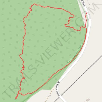
Mangaweka Scenic Track
- Distance: 1.0 mi
- Elevation gain: 80 m
- Maximum elevation: 426 m
- Elevation loss: 81 m
- Minimum elevation: 350 m
- Moving time: 27 m 14 s
- Moving speed: 2.2 mph
- Maximum speed: 6.2 mph
- Total time: 29 m 47 s
- Global speed: 2.0 mph
Interactive trail map
Thank you for supporting this site ❤️
Make a donation
Make a donation
Gear up for your next adventure:
As an Amazon Associate, this site earns from qualifying purchases at no extra cost to you.
Trail profile
- Distance: 1.0 mi
- Elevation gain: 80 m
- Maximum elevation: 426 m
- Elevation loss: 81 m
- Minimum elevation: 350 m
- Moving time: 27 m 14 s
- Moving speed: 2.2 mph
- Maximum speed: 6.2 mph
- Total time: 29 m 47 s
- Global speed: 2.0 mph
Thank you for supporting this site ❤️
Make a donation
Make a donation
Gear up for your next adventure:
As an Amazon Associate, this site earns from qualifying purchases at no extra cost to you.
About this trail
Name: Mangaweka Scenic Track trail, distance, elevation, map, profile, GPS track
Coordinates: -39.81239 175.78001 -39.80853 175.78381
Thank you for supporting this site ❤️
Make a donation
Make a donation
Gear up for your next adventure:
As an Amazon Associate, this site earns from qualifying purchases at no extra cost to you.