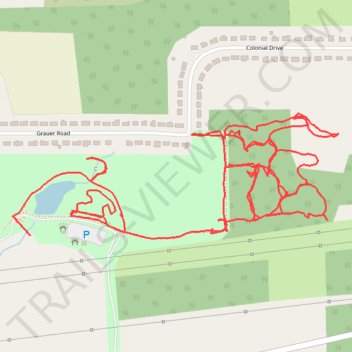
Town of Niagara Veterans Park boardwalk and nature trails
- Distance: 3.6 mi
- Elevation gain: 24 m
- Maximum elevation: 195 m
- Elevation loss: 20 m
- Minimum elevation: 184 m
- Moving time: 1 h 21 m
- Moving speed: 2.7 mph
- Maximum speed: 6.2 mph
- Total time: 1 h 22 m
- Global speed: 2.6 mph
Interactive trail map
Trail profile
- Distance: 3.6 mi
- Elevation gain: 24 m
- Maximum elevation: 195 m
- Elevation loss: 20 m
- Minimum elevation: 184 m
- Moving time: 1 h 21 m
- Moving speed: 2.7 mph
- Maximum speed: 6.2 mph
- Total time: 1 h 22 m
- Global speed: 2.6 mph
About this trail
Name: Town of Niagara Veterans Park boardwalk and nature trails trail, distance, elevation, map, profile, GPS track
Start: Grauer Road, Town of Niagara, Niagara County, New York, 14305, United States (43.12494 -78.99126)
Coordinates: 43.12486 -78.99186 43.12798 -78.98074
Other hiking, mountain biking, running and outdoor activity trails
Click on a trail to view its statistics, map and profile.