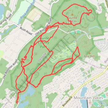
Tourne County Park Loop
- Distance: 10.3 mi
- Elevation gain: 325 m
- Maximum elevation: 244 m
- Elevation loss: 325 m
- Minimum elevation: 170 m
- Moving time: 1 h 36 m
- Moving speed: 6.4 mph
- Maximum speed: 20.4 mph
- Total time: 1 h 57 m
- Global speed: 5.3 mph
Interactive trail map
Trail profile
- Distance: 10.3 mi
- Elevation gain: 325 m
- Maximum elevation: 244 m
- Elevation loss: 325 m
- Minimum elevation: 170 m
- Moving time: 1 h 36 m
- Moving speed: 6.4 mph
- Maximum speed: 20.4 mph
- Total time: 1 h 57 m
- Global speed: 5.3 mph
About this trail
Name: Tourne County Park Loop trail, distance, elevation, map, profile, GPS track
Coordinates: 40.89349 -74.45340 40.91482 -74.43190
Other hiking, mountain biking, running and outdoor activity trails
Click on a trail to view its statistics, map and profile.
Tourne County Park trails
United States > New Jersey > Morris County > Mountain Lakes
Distance: 11.5 mi • Elevation gain: 362 m • Maximum elevation: 243 m
Tourne Park Yellow Trail
United States > New Jersey > Morris County > Boonton Township
Distance: 2.7 mi • Elevation gain: 139 m • Maximum elevation: 267 m
Tourne County Park loop
United States > New Jersey > Morris County > Mountain Lakes
Distance: 10.8 mi • Elevation gain: 352 m • Maximum elevation: 243 m
Tourne County Park
United States > New Jersey > Morris County > Mountain Lakes
Morning Mountain Bike Ride
Distance: 12.7 mi • Elevation gain: 400 m • Maximum elevation: 243 m