2025 VWD 14 km
<p>Van Papiermolenstraat 103;105, 9500 Geraardsbergen, België<br/>
Naar Papiermolenstraat 103;105, 9500 Geraardsbergen, België</p>
<p>Routering Kortste - OSM, Manueel</p>
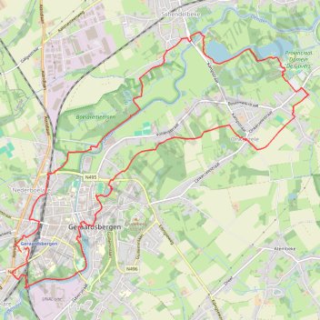
- Distance: 9.0 mi
- Elevation gain: 124 m
- Maximum elevation: 53 m
- Elevation loss: 125 m
- Minimum elevation: 7 m
Interactive trail map
Trail profile
- Distance: 9.0 mi
- Elevation gain: 124 m
- Maximum elevation: 53 m
- Elevation loss: 125 m
- Minimum elevation: 7 m
About this trail
Name: 2025 VWD 14 km trail, distance, elevation, map, profile, GPS track
Coordinates: 50.76425 3.86722 50.79468 3.92293
Other hiking, mountain biking, running and outdoor activity trails
Click on a trail to view its statistics, map and profile.
2025 MP 16 km
Belgium > East Flanders > Aalst > Geraardsbergen
<p>Van Zakkaai 29, 9500 Geraardsbergen, België<br/> Naar Denderstraat 35, 9500 Geraardsbergen, België</p> <p>Routering Kortste - OSM, Manueel</p>
Distance: 10.3 mi • Elevation gain: 265 m • Maximum elevation: 93 m