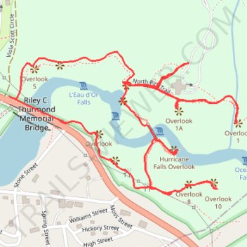
Tallulah Gorge Overlooks Loop via South and North Rim Trails
The Tallulah Gorge Overlooks Loop offers hikers a captivating journey through one of Georgia's most scenic state parks. Along the route, you'll encounter several breathtaking overlooks, including views of Tempesta Falls, Hurricane Falls, L'Eau d'Or Falls, and the expansive vistas of the gorge's steep walls. The trail also features the Hurricane Falls suspension bridge, which offers a unique perspective of the gorge and its waterfalls. The well-maintained trails provide a variety of perspectives, making this loop a must-do for nature enthusiasts seeking both beauty and adventure. #Hiking #Canyon #Gorge #Forest #Nature #River #Waterfall #Overlook #Loop
- Distance: 2.2 mi
- Elevation gain: 231 m
- Maximum elevation: 478 m
- Elevation loss: 231 m
- Minimum elevation: 385 m
- Moving time: 1 h 9 m
- Moving speed: 1.9 mph
- Maximum speed: 4.4 mph
- Total time: 1 h 37 m
- Global speed: 1.4 mph
Interactive trail map
Trail profile
- Distance: 2.2 mi
- Elevation gain: 231 m
- Maximum elevation: 478 m
- Elevation loss: 231 m
- Minimum elevation: 385 m
- Moving time: 1 h 9 m
- Moving speed: 1.9 mph
- Maximum speed: 4.4 mph
- Total time: 1 h 37 m
- Global speed: 1.4 mph
About this trail
Name: Tallulah Gorge Overlooks Loop via South and North Rim Trails trail, distance, elevation, map, profile, GPS track
Start: North Rim Trail, Tallulah Falls, Rabun County, Georgia, 30573, United States (34.74046 -83.39020)
End: North Rim Trail, Tallulah Falls, Rabun County, Georgia, 30573, United States (34.74049 -83.39023)
Coordinates: 34.73679 -83.39632 34.74078 -83.38854
Other hiking, mountain biking, running and outdoor activity trails
Click on a trail to view its statistics, map and profile.
Tallulah Gorge Overlooks Loop via North and South Rim Trails in Tallulah Gorge State Park
United States > Georgia > Rabun County > Tallulah Falls
The Tallulah Gorge Overlooks Loop offers an immersive experience in Georgia’s stunning Tallulah Gorge State Park. This loop provides sweeping views of the gorge, where hikers can catch glimpses of cascading waterfalls, including the multi-tiered L'Eau d'Or Falls, as well as Hurricane Falls, which is visible…
Distance: 1.7 mi • Elevation gain: 162 m • Maximum elevation: 476 m