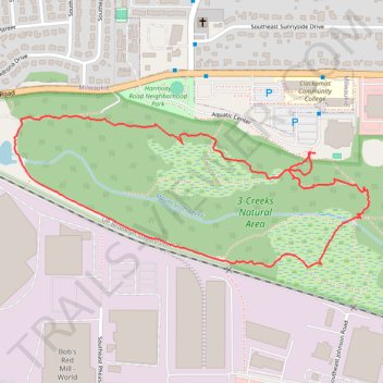
3-Creeks Natural Area loop
- Distance: 1.7 mi
- Elevation gain: 30 m
- Maximum elevation: 43 m
- Elevation loss: 30 m
- Minimum elevation: 23 m
- Moving time: 1 h 36 s
- Moving speed: 1.7 mph
- Maximum speed: 3.8 mph
- Total time: 1 h 54 m
- Global speed: 0.9 mph
Interactive trail map
Trail profile
- Distance: 1.7 mi
- Elevation gain: 30 m
- Maximum elevation: 43 m
- Elevation loss: 30 m
- Minimum elevation: 23 m
- Moving time: 1 h 36 s
- Moving speed: 1.7 mph
- Maximum speed: 3.8 mph
- Total time: 1 h 54 m
- Global speed: 0.9 mph
About this trail
Name: 3-Creeks Natural Area loop trail, distance, elevation, map, profile, GPS track
Coordinates: 45.42806 -122.59292 45.43158 -122.58120
Other hiking, mountain biking, running and outdoor activity trails
Click on a trail to view its statistics, map and profile.
The Watcher in the Water
United States > Oregon > Multnomah County > Portland
Distance: 51.5 mi • Elevation gain: 1,451 m • Maximum elevation: 300 m
Lake Oswego trails
United States > Oregon > Multnomah County > Portland
Happy Hour Lake Oswego
Distance: 43.2 mi • Elevation gain: 1,173 m • Maximum elevation: 222 m