Import a GPX file

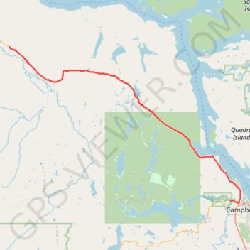
Campbell River - Sayward

Vancouver Island. #Bike #Campbell #Sayward #Vancouver

  • Distance: 38.4 mi
  • Elevation gain: 821 m
  • Maximum elevation: 312 m
  • Elevation loss: 811 m
  • Minimum elevation: 5 m

Interactive trail map

Trail profile

  • Distance: 38.4 mi
  • Elevation gain: 821 m
  • Maximum elevation: 312 m
  • Elevation loss: 811 m
  • Minimum elevation: 5 m

About this trail

Other hiking, mountain biking, running and outdoor activity trails

Click on a trail to view its statistics, map and profile.

Elk Falls Provincial Park Trail - Millenium Trail

Canada > British Columbia > Strathcona Regional District > Campbell River

Elk Falls Provincial Park. Vancouver Island. #Hiking #Loop #Elk #Vancouver

Distance: 2.3 mi • Elevation gain: 117 m • Maximum elevation: 154 m

Fanny Bay - Campbell River

Canada > British Columbia > Comox Valley Regional District > Area A (Baynes Sound)

Vancouver Island. #Bike #Fanny #Campbell #Vancouver

Distance: 49.1 mi • Elevation gain: 452 m • Maximum elevation: 93 m

Elk Falls Provincial Park Campground Loop via Millenium trail

Canada > British Columbia > Strathcona Regional District > Campbell River

Distance: 8.6 mi • Elevation gain: 413 m • Maximum elevation: 160 m

Gear up for your next adventure:

🧣Fleece Neck Warmers - Extra insulation for winter topographic surveys
🧢Hiking Hats - Sun and weather protection for outdoor walks
🐕Dog Hiking Gear - Equipment for hiking safely with dogs
🥼Base Layers - Thermal base layers for temperature regulation
📸Action Camera Chest Mounts - Record your ascent following topographic paths hands-free

As an Amazon Associate, this site earns from qualifying purchases at no extra cost to you.