Make a donation
Gear up for your next adventure:
As an Amazon Associate, this site earns from qualifying purchases at no extra cost to you.
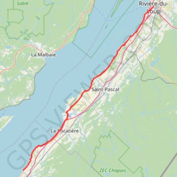
Saint-Jean-Port-Joli - Rivière-du-Loup
Saint Lawrence River. #Bike #SaintJeanPortJoli #RivièreDuLoup #SaintLawrence
- Distance: 58.1 mi
- Elevation gain: 371 m
- Maximum elevation: 58 m
- Elevation loss: 333 m
- Minimum elevation: 0 m
Interactive trail map
Make a donation
Gear up for your next adventure:
As an Amazon Associate, this site earns from qualifying purchases at no extra cost to you.
Trail profile
- Distance: 58.1 mi
- Elevation gain: 371 m
- Maximum elevation: 58 m
- Elevation loss: 333 m
- Minimum elevation: 0 m
Make a donation
Gear up for your next adventure:
As an Amazon Associate, this site earns from qualifying purchases at no extra cost to you.
About this trail
Name: Saint-Jean-Port-Joli - Rivière-du-Loup trail, distance, elevation, map, profile, GPS track
Coordinates: 47.21790 -70.26524 47.83703 -69.53546
Make a donation
Gear up for your next adventure:
As an Amazon Associate, this site earns from qualifying purchases at no extra cost to you.
Other hiking, mountain biking, running and outdoor activity trails
Click on a trail to view its statistics, map and profile.
Québec - Saint-Jean-Port-Joli
Canada > Quebec > Urban agglomeration of Québec > Quebec
Saint Lawrence River. #Bike #Québec #SaintJeanPortJoli
Distance: 59.2 mi • Elevation gain: 476 m • Maximum elevation: 82 m
Rivière-du-Loup - Rimouski
Canada > Quebec > Rivière-du-Loup (MRC) > Rivière-du-Loup
Saint Lawrence River. #Bike #RivièreDuLoup #Rimouski #SaintLawrence
Distance: 62.4 mi • Elevation gain: 533 m • Maximum elevation: 121 m
Rivière-du-Loup - Témiscouata-sur-le-Lac
Canada > Quebec > Rivière-du-Loup (MRC) > Rivière-du-Loup
#Bike #RivièreDuLoup #Témiscouata
Distance: 44.6 mi • Elevation gain: 581 m • Maximum elevation: 406 m