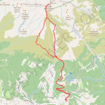
Traccia corrente: 13 MAR 2016 07:40
- Distance: 3.9 mi
- Elevation gain: 904 m
- Maximum elevation: 2,153 m
- Elevation loss: 902 m
- Minimum elevation: 1,284 m
- Moving time: 2 h 41 m
- Moving speed: 1.4 mph
- Maximum speed: 3.8 mph
- Total time: 4 h 38 m
- Global speed: 0.8 mph
Interactive trail map
Trail profile
- Distance: 3.9 mi
- Elevation gain: 904 m
- Maximum elevation: 2,153 m
- Elevation loss: 902 m
- Minimum elevation: 1,284 m
- Moving time: 2 h 41 m
- Moving speed: 1.4 mph
- Maximum speed: 3.8 mph
- Total time: 4 h 38 m
- Global speed: 0.8 mph
About this trail
Name: Traccia corrente: 13 MAR 2016 07:40 trail, distance, elevation, map, profile, GPS track
Start: Via Carlo Mauri, Ballabio, Lecco, Lombardy, 23811, Italy (45.90569 9.39508)
Coordinates: 45.90569 9.38755 45.92199 9.39570