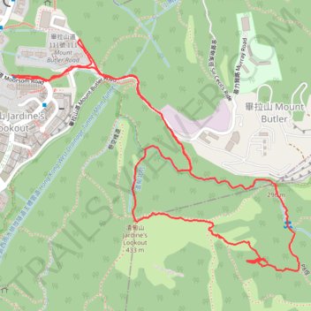
渣甸北坑 渣甸東石河
Loop hike
- Distance: 2.6 mi
- Elevation gain: 353 m
- Maximum elevation: 410 m
- Elevation loss: 354 m
- Minimum elevation: 177 m
- Moving time: 1 h 16 m
- Moving speed: 2.1 mph
- Maximum speed: 19.0 mph
- Total time: 2 h 15 m
- Global speed: 1.2 mph
Interactive trail map
Trail profile
- Distance: 2.6 mi
- Elevation gain: 353 m
- Maximum elevation: 410 m
- Elevation loss: 354 m
- Minimum elevation: 177 m
- Moving time: 1 h 16 m
- Moving speed: 2.1 mph
- Maximum speed: 19.0 mph
- Total time: 2 h 15 m
- Global speed: 1.2 mph
About this trail
Name: 渣甸北坑 渣甸東石河 trail, distance, elevation, map, profile, GPS track
Coordinates: 22.26470 114.19411 22.27206 114.20399
Other hiking, mountain biking, running and outdoor activity trails
Click on a trail to view its statistics, map and profile.
Wilson Trail
China > Hong Kong > Hong Kong Island
Distance: 8.1 mi • Elevation gain: 1,032 m • Maximum elevation: 410 m
Wilson Trail Full Route
China > Hong Kong > Hong Kong Island
Distance: 50.5 mi • Elevation gain: 4,430 m • Maximum elevation: 613 m
Hong Kong island ride
China > Hong Kong > Hong Kong Island
#Bike
Distance: 38.4 mi • Elevation gain: 2,152 m • Maximum elevation: 505 m
Jardine's Lookout
China > Hong Kong > Hong Kong Island
Distance: 3.8 mi • Elevation gain: 350 m • Maximum elevation: 410 m
Trail Planner Map
China > Hong Kong > Hong Kong Island
Distance: 12.6 mi • Elevation gain: 1,151 m • Maximum elevation: 423 m
畢鰂 紫潭北坑
China > Hong Kong > Hong Kong Island
Eastern District Hike
Distance: 5.5 mi • Elevation gain: 587 m • Maximum elevation: 408 m