Make a donation
Gear up for your next adventure:
As an Amazon Associate, this site earns from qualifying purchases at no extra cost to you.
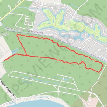
Woodlands Conservatory Loop Trail in New Orleans
The Woodlands Conservancy Loop Trail offers a serene hike through lush wetlands and forested areas, allowing visitors to immerse themselves in local wildlife and native vegetation. The trail winds through hardwood forests and scenic waterways, providing opportunities to observe a variety of birds and other wildlife. One of the unique highlights is a glimpse of historic World War II ammunition magazines, tucked away toward the end of the trail, blending nature with history. #Hiking #Loop #Forest #Nature
- Distance: 5.2 mi
- Elevation gain: 8 m
- Maximum elevation: 4 m
- Elevation loss: 9 m
- Minimum elevation: -1 m
- Moving time: 2 h 20 m
- Moving speed: 2.2 mph
- Maximum speed: 5.0 mph
- Total time: 2 h 34 m
- Global speed: 2.0 mph
Interactive trail map
Make a donation
Gear up for your next adventure:
As an Amazon Associate, this site earns from qualifying purchases at no extra cost to you.
Trail profile
- Distance: 5.2 mi
- Elevation gain: 8 m
- Maximum elevation: 4 m
- Elevation loss: 9 m
- Minimum elevation: -1 m
- Moving time: 2 h 20 m
- Moving speed: 2.2 mph
- Maximum speed: 5.0 mph
- Total time: 2 h 34 m
- Global speed: 2.0 mph
Make a donation
Gear up for your next adventure:
As an Amazon Associate, this site earns from qualifying purchases at no extra cost to you.
About this trail
Name: Woodlands Conservatory Loop Trail in New Orleans trail, distance, elevation, map, profile, GPS track
Start: Belle Chasse, Plaquemines Parish, Louisiana, 70131, United States (29.89597 -89.97344)
End: Belle Chasse, Plaquemines Parish, Louisiana, 70131, United States (29.89580 -89.97378)
Coordinates: 29.89254 -89.97378 29.90302 -89.94226
Make a donation
Gear up for your next adventure:
As an Amazon Associate, this site earns from qualifying purchases at no extra cost to you.