Thank you for supporting this site ❤️
Make a donation
Make a donation
Gear up for your next adventure:
As an Amazon Associate, this site earns from qualifying purchases at no extra cost to you.
Maidstone Park Loop Walk
- Distance: 2.6 mi
- Elevation gain: 157 m
- Maximum elevation: 175 m
- Elevation loss: 157 m
- Minimum elevation: 64 m
- Moving time: 1 h 18 m
- Moving speed: 2.0 mph
- Maximum speed: 4.6 mph
- Total time: 1 h 29 m
- Global speed: 1.7 mph
Interactive trail map
Thank you for supporting this site ❤️
Make a donation
Make a donation
Gear up for your next adventure:
As an Amazon Associate, this site earns from qualifying purchases at no extra cost to you.
Trail profile
- Distance: 2.6 mi
- Elevation gain: 157 m
- Maximum elevation: 175 m
- Elevation loss: 157 m
- Minimum elevation: 64 m
- Moving time: 1 h 18 m
- Moving speed: 2.0 mph
- Maximum speed: 4.6 mph
- Total time: 1 h 29 m
- Global speed: 1.7 mph
Thank you for supporting this site ❤️
Make a donation
Make a donation
Gear up for your next adventure:
As an Amazon Associate, this site earns from qualifying purchases at no extra cost to you.
About this trail
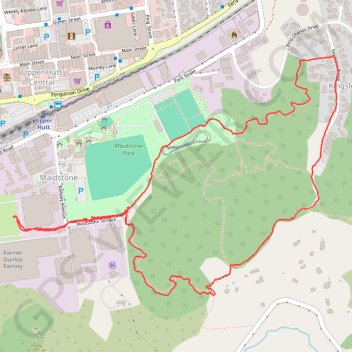
Name: Maidstone Park Loop Walk trail, distance, elevation, map, profile, GPS track
Coordinates: -41.13186 175.06929 -41.12430 175.08299
Thank you for supporting this site ❤️
Make a donation
Make a donation
Gear up for your next adventure:
As an Amazon Associate, this site earns from qualifying purchases at no extra cost to you.