Thank you for supporting this site ❤️
Make a donation
Make a donation
Gear up for your next adventure:
As an Amazon Associate, this site earns from qualifying purchases at no extra cost to you.
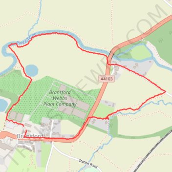
River Teme
- Distance: 2.1 mi
- Elevation gain: 21 m
- Maximum elevation: 38 m
- Elevation loss: 21 m
- Minimum elevation: 18 m
- Moving time: 49 m 39 s
- Moving speed: 2.6 mph
- Maximum speed: 6.0 mph
- Total time: 53 m 14 s
- Global speed: 2.4 mph
Interactive trail map
Thank you for supporting this site ❤️
Make a donation
Make a donation
Gear up for your next adventure:
As an Amazon Associate, this site earns from qualifying purchases at no extra cost to you.
Trail profile
- Distance: 2.1 mi
- Elevation gain: 21 m
- Maximum elevation: 38 m
- Elevation loss: 21 m
- Minimum elevation: 18 m
- Moving time: 49 m 39 s
- Moving speed: 2.6 mph
- Maximum speed: 6.0 mph
- Total time: 53 m 14 s
- Global speed: 2.4 mph
Thank you for supporting this site ❤️
Make a donation
Make a donation
Gear up for your next adventure:
As an Amazon Associate, this site earns from qualifying purchases at no extra cost to you.
About this trail
Name: River Teme trail, distance, elevation, map, profile, GPS track
Coordinates: 52.17152 -2.29916 52.17836 -2.28249
Topography: Malvern Hills topographic map, elevation, terrain
Thank you for supporting this site ❤️
Make a donation
Make a donation
Gear up for your next adventure:
As an Amazon Associate, this site earns from qualifying purchases at no extra cost to you.