Import a GPX file

Munro hillwalk Sgurr Mhaoriach

#Munro #Hillwalk #Mhaoriach

  • Distance: 10.0 mi
  • Elevation gain: 1,100 m
  • Maximum elevation: 1,020 m
  • Elevation loss: 1,100 m
  • Minimum elevation: 211 m
  • Moving time: 4 h 50 m
  • Moving speed: 2.1 mph
  • Maximum speed: 5.9 mph
  • Total time: 5 h 4 m
  • Global speed: 2.0 mph

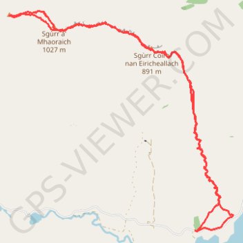
Interactive trail map

Trail profile

  • Distance: 10.0 mi
  • Elevation gain: 1,100 m
  • Maximum elevation: 1,020 m
  • Elevation loss: 1,100 m
  • Minimum elevation: 211 m
  • Moving time: 4 h 50 m
  • Moving speed: 2.1 mph
  • Maximum speed: 5.9 mph
  • Total time: 5 h 4 m
  • Global speed: 2.0 mph

About this trail

Name: Munro hillwalk Sgurr Mhaoriach trail, distance, elevation, map, profile, GPS track

Start: Highland, Scotland, United Kingdom (57.07720 -5.29433)

End: Highland, Scotland, United Kingdom (57.07718 -5.29421)

Coordinates: 57.07707 -5.34172 57.10761 -5.28449

Topography: Highland topographic map, elevation, terrain

Gear up for your next adventure:

Camping Shelters - Emergency and lightweight shelters for outdoor use
Lightweight Tents - Compact tents for backpacking and trekking
🐕Hiking Dog Harnesses - Rugged harnesses for taking your companion on mountain trails
🧦Hiking Socks - Breathable socks designed to prevent blisters on long walks
Insulated Travel Mugs - Keep drinks hot while surveying the landscape from a summit

As an Amazon Associate, this site earns from qualifying purchases at no extra cost to you.