Two Rivers State Recreation Area Loop Walk
- Distance: 2.1 mi
- Elevation gain: 11 m
- Maximum elevation: 346 m
- Elevation loss: 11 m
- Minimum elevation: 340 m
- Moving time: 38 m 32 s
- Moving speed: 3.2 mph
- Maximum speed: 4.2 mph
- Total time: 39 m 5 s
- Global speed: 3.2 mph
Interactive trail map
Trail profile
- Distance: 2.1 mi
- Elevation gain: 11 m
- Maximum elevation: 346 m
- Elevation loss: 11 m
- Minimum elevation: 340 m
- Moving time: 38 m 32 s
- Moving speed: 3.2 mph
- Maximum speed: 4.2 mph
- Total time: 39 m 5 s
- Global speed: 3.2 mph
About this trail
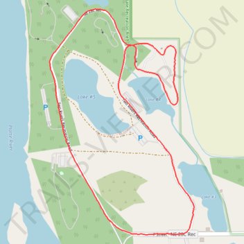
Name: Two Rivers State Recreation Area Loop Walk trail, distance, elevation, map, profile, GPS track
Coordinates: 41.21916 -96.35762 41.22758 -96.35045
Other hiking, mountain biking, running and outdoor activity trails
Click on a trail to view its statistics, map and profile.
Two Rivers State Recreation Area Loop Walk
United States > Nebraska > Douglas County > Venice
Distance: 2.6 mi • Elevation gain: 20 m • Maximum elevation: 348 m
Hiking at Two Rivers State Recreation Area
United States > Nebraska > Douglas County
Distance: 3.1 mi • Elevation gain: 17 m • Maximum elevation: 346 m