Santiago Peak
Hike to Santiago Peak via Indian Truck Trail in Cleveland National Forest. #Hiking #Mountain #Nature #Forest
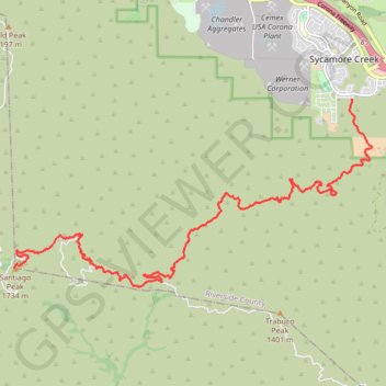
- Distance: 10.5 mi
- Elevation gain: 1,653 m
- Maximum elevation: 1,727 m
- Elevation loss: 317 m
- Minimum elevation: 389 m
- Moving time: 1 h 40 m
- Moving speed: 6.3 mph
- Maximum speed: 7.7 mph
- Total time: 1 h 40 m
- Global speed: 6.3 mph
Interactive trail map
Trail profile
- Distance: 10.5 mi
- Elevation gain: 1,653 m
- Maximum elevation: 1,727 m
- Elevation loss: 317 m
- Minimum elevation: 389 m
- Moving time: 1 h 40 m
- Moving speed: 6.3 mph
- Maximum speed: 7.7 mph
- Total time: 1 h 40 m
- Global speed: 6.3 mph
About this trail
Name: Santiago Peak trail, distance, elevation, map, profile, GPS track
End: North Main Divide Road, Orange County, California, United States (33.71070 -117.53424)
Coordinates: 33.70711 -117.53424 33.74206 -117.45445
Other hiking, mountain biking, running and outdoor activity trails
Click on a trail to view its statistics, map and profile.