Mauna Kea (Hawaii)
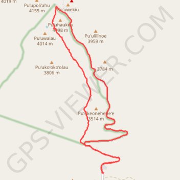
Starting at the Maunakea Visitor Information Station, near Puʻukalepeamoa and Puʻuhauwahine, this demanding loop follows the Mauna Kea–Humuʻula Trail from the upper edge of the Mauna Kea Forest Reserve into a wide volcanic landscape of cinder, lava, and sparse alpine vegetation.
As the route enters the Mauna Kea Ice Age Natural Area Reserve, the scenery becomes increasingly austere and high-mountain in character, passing below Puʻukeoheheʻe and toward the upper summit slopes, with broad views across Hawaiʻi Island and notable natural features such as Keanakākoʻi and Lake Waiau adding geological, ecological, and cultural depth to the ascent.
Near the top, the itinerary reaches the summit area around Puʻu Wēkiu and Mauna Kea, close to the observatory zone and the Mauna Kea Access Road, before returning by a combination of road bends and trail sections through the same exposed volcanic terrain, making this a striking high-altitude circuit that calls for preparation, respect for the sacred landscape, and caution in rapidly changing mountain conditions.
#Hiking #Loop #Mountain #Volcano #Nature #Hawaii #Island
- Distance: 13.2 mi
- Elevation gain: 1,256 m
- Maximum elevation: 4,037 m
- Elevation loss: 1,257 m
- Minimum elevation: 2,800 m
Interactive trail map
Trail profile
- Distance: 13.2 mi
- Elevation gain: 1,256 m
- Maximum elevation: 4,037 m
- Elevation loss: 1,257 m
- Minimum elevation: 2,800 m
About this trail
Name: Mauna Kea (Hawaii) trail, distance, elevation, map, profile, GPS track
Coordinates: 19.75911 -155.47522 19.81847 -155.44687
Other hiking, mountain biking, running and outdoor activity trails
Click on a trail to view its statistics, map and profile.
Mauna Kea Visitor Center Puu Kalepeamoa Trail
United States > Hawaii > Hawaiʻi County
Distance: 1.4 mi • Elevation gain: 72 m • Maximum elevation: 2,852 m
Mauna Kea's Humu'ula Trail
United States > Hawaii > Hawaiʻi County
Distance: 12.9 mi • Elevation gain: 1,421 m • Maximum elevation: 4,207 m