Make a donation
Gear up for your next adventure:
As an Amazon Associate, this site earns from qualifying purchases at no extra cost to you.
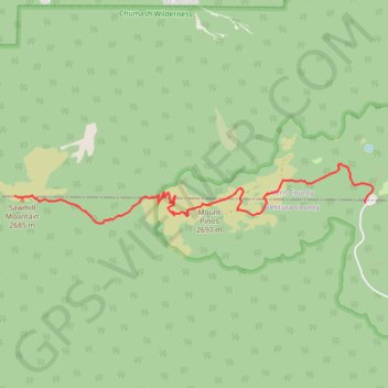
Sawmill Mountain and Mount Pinos
Hike to Sawmill Mountain via Mount Pinos Condor Observation Site from Chula Vista Parking in the Chumash Wilderness. #Hiking #Mountain #Nature #Forest #Wilderness
- Distance: 3.7 mi
- Elevation gain: 311 m
- Maximum elevation: 2,692 m
- Elevation loss: 185 m
- Minimum elevation: 2,548 m
Interactive trail map
Make a donation
Gear up for your next adventure:
As an Amazon Associate, this site earns from qualifying purchases at no extra cost to you.
Trail profile
- Distance: 3.7 mi
- Elevation gain: 311 m
- Maximum elevation: 2,692 m
- Elevation loss: 185 m
- Minimum elevation: 2,548 m
Make a donation
Gear up for your next adventure:
As an Amazon Associate, this site earns from qualifying purchases at no extra cost to you.
About this trail
Name: Sawmill Mountain and Mount Pinos trail, distance, elevation, map, profile, GPS track
End: Vincent Tumamait Trail, Ventura County, California, 93222, United States (34.81364 -119.16798)
Coordinates: 34.81098 -119.16798 34.81666 -119.12625
Make a donation
Gear up for your next adventure:
As an Amazon Associate, this site earns from qualifying purchases at no extra cost to you.