Thank you for supporting this site ❤️
Make a donation
Make a donation
Gear up for your next adventure:
As an Amazon Associate, this site earns from qualifying purchases at no extra cost to you.
Maryland Mountain Biking
- Distance: 10.0 mi
- Elevation gain: 470 m
- Maximum elevation: 2,787 m
- Elevation loss: 468 m
- Minimum elevation: 2,501 m
- Moving time: 1 h 37 m
- Moving speed: 6.1 mph
- Maximum speed: 21.9 mph
- Total time: 2 h 15 m
- Global speed: 4.4 mph
Interactive trail map
Thank you for supporting this site ❤️
Make a donation
Make a donation
Gear up for your next adventure:
As an Amazon Associate, this site earns from qualifying purchases at no extra cost to you.
Trail profile
- Distance: 10.0 mi
- Elevation gain: 470 m
- Maximum elevation: 2,787 m
- Elevation loss: 468 m
- Minimum elevation: 2,501 m
- Moving time: 1 h 37 m
- Moving speed: 6.1 mph
- Maximum speed: 21.9 mph
- Total time: 2 h 15 m
- Global speed: 4.4 mph
Thank you for supporting this site ❤️
Make a donation
Make a donation
Gear up for your next adventure:
As an Amazon Associate, this site earns from qualifying purchases at no extra cost to you.
About this trail
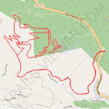
Name: Maryland Mountain Biking trail, distance, elevation, map, profile, GPS track
Start: Hidden Treasure Trail, Gilpin County, Colorado, 80422, United States (39.81133 -105.49650)
Coordinates: 39.80440 -105.51746 39.81719 -105.49639
Thank you for supporting this site ❤️
Make a donation
Make a donation
Gear up for your next adventure:
As an Amazon Associate, this site earns from qualifying purchases at no extra cost to you.