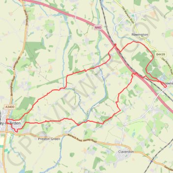
Henley-in-Arden to Shrewley trailrun
- Distance: 12.2 mi
- Elevation gain: 284 m
- Maximum elevation: 124 m
- Elevation loss: 285 m
- Minimum elevation: 72 m
- Moving time: 2 h 4 m
- Moving speed: 5.9 mph
- Maximum speed: 11.1 mph
- Total time: 2 h 6 m
- Global speed: 5.8 mph
Interactive trail map
Trail profile
- Distance: 12.2 mi
- Elevation gain: 284 m
- Maximum elevation: 124 m
- Elevation loss: 285 m
- Minimum elevation: 72 m
- Moving time: 2 h 4 m
- Moving speed: 5.9 mph
- Maximum speed: 11.1 mph
- Total time: 2 h 6 m
- Global speed: 5.8 mph
About this trail
Name: Henley-in-Arden to Shrewley trailrun trail, distance, elevation, map, profile, GPS track
Coordinates: 52.28745 -1.78023 52.31970 -1.68757
Topography: Stratford-on-Avon topographic map, elevation, terrain
Other hiking, mountain biking, running and outdoor activity trails
Click on a trail to view its statistics, map and profile.
Henley-in-Arden 🔁 Little Alne
United Kingdom > England > Warwickshire > Stratford-on-Avon > Henley-in-Arden
Distance: 11.4 mi • Elevation gain: 175 m • Maximum elevation: 110 m
Trailrun Warwick-Shrewley
United Kingdom > England > Warwickshire > Warwick > Budbrooke
Distance: 14.3 mi • Elevation gain: 184 m • Maximum elevation: 126 m