Thank you for supporting this site ❤️
Make a donation
Make a donation
Gear up for your next adventure:
As an Amazon Associate, this site earns from qualifying purchases at no extra cost to you.
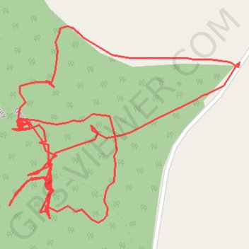
RE SJ800240
- Distance: 1.2 mi
- Elevation gain: 33 m
- Maximum elevation: 137 m
- Elevation loss: 33 m
- Minimum elevation: 117 m
- Moving time: 36 m 39 s
- Moving speed: 1.9 mph
- Maximum speed: 3.3 mph
- Total time: 3 h 31 m
- Global speed: 0.3 mph
Interactive trail map
Thank you for supporting this site ❤️
Make a donation
Make a donation
Gear up for your next adventure:
As an Amazon Associate, this site earns from qualifying purchases at no extra cost to you.
Trail profile
- Distance: 1.2 mi
- Elevation gain: 33 m
- Maximum elevation: 137 m
- Elevation loss: 33 m
- Minimum elevation: 117 m
- Moving time: 36 m 39 s
- Moving speed: 1.9 mph
- Maximum speed: 3.3 mph
- Total time: 3 h 31 m
- Global speed: 0.3 mph
Thank you for supporting this site ❤️
Make a donation
Make a donation
Gear up for your next adventure:
As an Amazon Associate, this site earns from qualifying purchases at no extra cost to you.
About this trail
Name: RE SJ800240 trail, distance, elevation, map, profile, GPS track
Coordinates: 52.81303 -2.29838 52.81499 -2.29458
Topography: Staffordshire topographic map, elevation, terrain
Thank you for supporting this site ❤️
Make a donation
Make a donation
Gear up for your next adventure:
As an Amazon Associate, this site earns from qualifying purchases at no extra cost to you.
Other hiking, mountain biking, running and outdoor activity trails
Click on a trail to view its statistics, map and profile.
RE SJ800240 2
United Kingdom > England > Staffordshire > Stafford > Gnosall > Knightley
Distance: 1.5 mi • Elevation gain: 31 m • Maximum elevation: 137 m