
Lake Blanche Trail and Lake Blanche Loop in the Twin Peaks Wilderness
The Lake Blanche Trail offers a challenging ascent that rewards hikers with breathtaking views of Sundial Peak and the expansive valley below unfold. As you make your way up the rocky path, the serene beauty of Lake Blanche awaits at the top, surrounded by stunning vistas that make every effort worthwhile. #Hiking #Mountain #Lake #River #Forest #Nature
- Distance: 7.7 mi
- Elevation gain: 854 m
- Maximum elevation: 2,736 m
- Elevation loss: 858 m
- Minimum elevation: 1,901 m
- Moving time: 3 h 5 m
- Moving speed: 2.5 mph
- Maximum speed: 5.9 mph
- Total time: 3 h 56 m
- Global speed: 2.0 mph
Interactive trail map
Trail profile
- Distance: 7.7 mi
- Elevation gain: 854 m
- Maximum elevation: 2,736 m
- Elevation loss: 858 m
- Minimum elevation: 1,901 m
- Moving time: 3 h 5 m
- Moving speed: 2.5 mph
- Maximum speed: 5.9 mph
- Total time: 3 h 56 m
- Global speed: 2.0 mph
About this trail
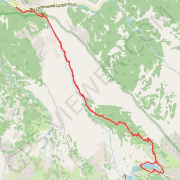
Name: Lake Blanche Trail and Lake Blanche Loop in the Twin Peaks Wilderness trail, distance, elevation, map, profile, GPS track
End: Big Cottonwood Canyon Road, Salt Lake County, Utah, United States (40.63362 -111.72372)
Coordinates: 40.60447 -111.72372 40.63362 -111.68973
Other hiking, mountain biking, running and outdoor activity trails
Click on a trail to view its statistics, map and profile.
Lake Blanche Trail
United States > Utah > Salt Lake County
Distance: 7.8 mi • Elevation gain: 854 m • Maximum elevation: 2,716 m