Make a donation
Gear up for your next adventure:
As an Amazon Associate, this site earns from qualifying purchases at no extra cost to you.
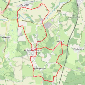
Hertfordshire Chain Walk 3&4
- Distance: 12.1 mi
- Elevation gain: 224 m
- Maximum elevation: 129 m
- Elevation loss: 224 m
- Minimum elevation: 48 m
- Moving time: 3 h 53 m
- Moving speed: 3.1 mph
- Maximum speed: 3.3 mph
- Total time: 3 h 53 m
- Global speed: 3.1 mph
Interactive trail map
Make a donation
Gear up for your next adventure:
As an Amazon Associate, this site earns from qualifying purchases at no extra cost to you.
Trail profile
- Distance: 12.1 mi
- Elevation gain: 224 m
- Maximum elevation: 129 m
- Elevation loss: 224 m
- Minimum elevation: 48 m
- Moving time: 3 h 53 m
- Moving speed: 3.1 mph
- Maximum speed: 3.3 mph
- Total time: 3 h 53 m
- Global speed: 3.1 mph
Make a donation
Gear up for your next adventure:
As an Amazon Associate, this site earns from qualifying purchases at no extra cost to you.
About this trail
Name: Hertfordshire Chain Walk 3&4 trail, distance, elevation, map, profile, GPS track
Coordinates: 51.73612 -0.14352 51.78231 -0.09552
Topography: East Hertfordshire topographic map, elevation, terrain
Make a donation
Gear up for your next adventure:
As an Amazon Associate, this site earns from qualifying purchases at no extra cost to you.
Other hiking, mountain biking, running and outdoor activity trails
Click on a trail to view its statistics, map and profile.
Circuit from Broxbourne Woods
United Kingdom > England > Hertfordshire > East Hertfordshire > Brickendon
Broxbourne woods
Distance: 8.5 mi • Elevation gain: 169 m • Maximum elevation: 117 m