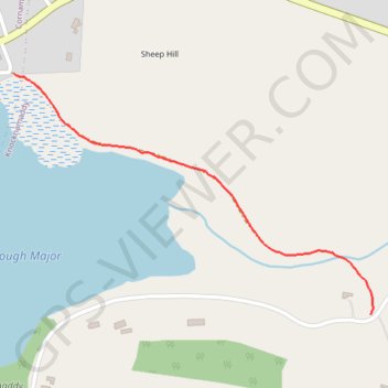
Thank you for supporting this site ❤️
Make a donation
Make a donation
Gear up for your next adventure:
As an Amazon Associate, this site earns from qualifying purchases at no extra cost to you.
Coachman's Walk
Lough Major
- Distance: 0.5 mi
- Elevation gain: 11 m
- Maximum elevation: 88 m
- Elevation loss: 3 m
- Minimum elevation: 78 m
- Moving time: 10 m 13 s
- Moving speed: 3.0 mph
- Maximum speed: 4.0 mph
- Total time: 10 m 13 s
- Global speed: 3.0 mph
Interactive trail map
Thank you for supporting this site ❤️
Make a donation
Make a donation
Gear up for your next adventure:
As an Amazon Associate, this site earns from qualifying purchases at no extra cost to you.
Trail profile
- Distance: 0.5 mi
- Elevation gain: 11 m
- Maximum elevation: 88 m
- Elevation loss: 3 m
- Minimum elevation: 78 m
- Moving time: 10 m 13 s
- Moving speed: 3.0 mph
- Maximum speed: 4.0 mph
- Total time: 10 m 13 s
- Global speed: 3.0 mph
Thank you for supporting this site ❤️
Make a donation
Make a donation
Gear up for your next adventure:
As an Amazon Associate, this site earns from qualifying purchases at no extra cost to you.
About this trail
Name: Coachman's Walk trail, distance, elevation, map, profile, GPS track
Coordinates: 54.12636 -6.89228 54.13013 -6.88270
Thank you for supporting this site ❤️
Make a donation
Make a donation
Gear up for your next adventure:
As an Amazon Associate, this site earns from qualifying purchases at no extra cost to you.