Bešnjaja, kanjon Voljevice
- Distance: 10.1 mi
- Elevation gain: 681 m
- Maximum elevation: 565 m
- Elevation loss: 681 m
- Minimum elevation: 297 m
- Moving time: 4 h 23 m
- Moving speed: 2.3 mph
- Maximum speed: 4.7 mph
- Total time: 6 h 4 m
- Global speed: 1.7 mph
Interactive trail map
Trail profile
- Distance: 10.1 mi
- Elevation gain: 681 m
- Maximum elevation: 565 m
- Elevation loss: 681 m
- Minimum elevation: 297 m
- Moving time: 4 h 23 m
- Moving speed: 2.3 mph
- Maximum speed: 4.7 mph
- Total time: 6 h 4 m
- Global speed: 1.7 mph
About this trail
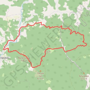
Name: Bešnjaja, kanjon Voljevice trail, distance, elevation, map, profile, GPS track
Coordinates: 43.98132 21.00311 44.00700 21.06836
Other hiking, mountain biking, running and outdoor activity trails
Click on a trail to view its statistics, map and profile.
2022_Yu
Slovenia > Ajdovščina > Žapuže
Distance: 1,526.9 mi • Elevation gain: 32,048 m • Maximum elevation: 1,950 m