Make a donation
Gear up for your next adventure:
As an Amazon Associate, this site earns from qualifying purchases at no extra cost to you.
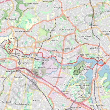
Wentworth Point - Parramatta Park
Morning Ride
- Distance: 20.4 mi
- Elevation gain: 268 m
- Maximum elevation: 32 m
- Elevation loss: 267 m
- Minimum elevation: -1 m
- Moving time: 1 h 24 m
- Moving speed: 14.5 mph
- Maximum speed: 24.6 mph
- Total time: 1 h 39 m
- Global speed: 12.4 mph
Interactive trail map
Make a donation
Gear up for your next adventure:
As an Amazon Associate, this site earns from qualifying purchases at no extra cost to you.
Trail profile
- Distance: 20.4 mi
- Elevation gain: 268 m
- Maximum elevation: 32 m
- Elevation loss: 267 m
- Minimum elevation: -1 m
- Moving time: 1 h 24 m
- Moving speed: 14.5 mph
- Maximum speed: 24.6 mph
- Total time: 1 h 39 m
- Global speed: 12.4 mph
Make a donation
Gear up for your next adventure:
As an Amazon Associate, this site earns from qualifying purchases at no extra cost to you.
About this trail
Name: Wentworth Point - Parramatta Park trail, distance, elevation, map, profile, GPS track
Coordinates: -33.82812 150.99180 -33.80331 151.09746
Make a donation
Gear up for your next adventure:
As an Amazon Associate, this site earns from qualifying purchases at no extra cost to you.
Other hiking, mountain biking, running and outdoor activity trails
Click on a trail to view its statistics, map and profile.
Parramatta Valley Cycleway and Parramatta Park Loop Ride
Australia > New South Wales > Sydney
The Parramatta Valley Cycleway and Parramatta Park Loop Ride offer a delightful escape into nature, winding alongside the picturesque Parramatta River. You'll encounter stunning views of the river, charming heritage sites like Old Government House, and the lush greenery of Parramatta Park, making it a perfect…
Distance: 19.8 mi • Elevation gain: 273 m • Maximum elevation: 32 m
The Ponds Walk: Carlingford - Rydalmere
Australia > New South Wales > Sydney
Distance: 4.9 mi • Elevation gain: 27 m • Maximum elevation: 127 m
Sydney Loop Ride via Homebush Bay, Powells Creek, Hudson Park, Cooks River Cycleway, Cooks to Cove Greenway, Hawthorne Canal and Iron Cove
Australia > New South Wales > Sydney
Distance: 33.9 mi • Elevation gain: 343 m • Maximum elevation: 34 m
Ride to George Kindall Riverside Park
Australia > New South Wales > Sydney
Distance: 8.7 mi • Elevation gain: 125 m • Maximum elevation: 21 m
Make a donation
Gear up for your next adventure:
As an Amazon Associate, this site earns from qualifying purchases at no extra cost to you.
Parramatta River Afternoon Ride
Australia > New South Wales > Sydney
Distance: 15.1 mi • Elevation gain: 211 m • Maximum elevation: 32 m
Parramatta River Morning Ride
Australia > New South Wales > Sydney
Distance: 14.9 mi • Elevation gain: 206 m • Maximum elevation: 32 m
Parramatta Ride
Australia > New South Wales > Sydney
Afternoon Ride
Distance: 17.0 mi • Elevation gain: 239 m • Maximum elevation: 32 m
Parramatta River
Australia > New South Wales > Sydney
Morning Ride
Distance: 19.5 mi • Elevation gain: 284 m • Maximum elevation: 32 m
Make a donation
Gear up for your next adventure:
As an Amazon Associate, this site earns from qualifying purchases at no extra cost to you.
Auburn Circle
Australia > New South Wales > Sydney
Distance: 17.3 mi • Elevation gain: 108 m • Maximum elevation: 37 m
Lunch Ride
Australia > New South Wales > Sydney
Distance: 17.5 mi • Elevation gain: 231 m • Maximum elevation: 32 m