Make a donation
Gear up for your next adventure:
As an Amazon Associate, this site earns from qualifying purchases at no extra cost to you.
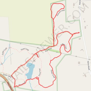
Rock House Reservation via eastern Outer Loop, Fullan Trail, Summit Loop & Fire Road
Rock House Reservation, West Brookfield, Massachusetts
- Distance: 2.2 mi
- Elevation gain: 89 m
- Maximum elevation: 311 m
- Elevation loss: 90 m
- Minimum elevation: 242 m
- Moving time: 1 h 11 m
- Moving speed: 1.8 mph
- Maximum speed: 3.6 mph
- Total time: 1 h 21 m
- Global speed: 1.6 mph
Interactive trail map
Make a donation
Gear up for your next adventure:
As an Amazon Associate, this site earns from qualifying purchases at no extra cost to you.
Trail profile
- Distance: 2.2 mi
- Elevation gain: 89 m
- Maximum elevation: 311 m
- Elevation loss: 90 m
- Minimum elevation: 242 m
- Moving time: 1 h 11 m
- Moving speed: 1.8 mph
- Maximum speed: 3.6 mph
- Total time: 1 h 21 m
- Global speed: 1.6 mph
Make a donation
Gear up for your next adventure:
As an Amazon Associate, this site earns from qualifying purchases at no extra cost to you.
About this trail
Name: Rock House Reservation via eastern Outer Loop, Fullan Trail, Summit Loop & Fire Road trail, distance, elevation, map, profile, GPS track
Coordinates: 42.26815 -72.19880 42.27539 -72.19089
Make a donation
Gear up for your next adventure:
As an Amazon Associate, this site earns from qualifying purchases at no extra cost to you.
Other hiking, mountain biking, running and outdoor activity trails
Click on a trail to view its statistics, map and profile.
Walk at Rock House Reservation, on Pond Trail and western Outer Loop to Fire Road
United States > Massachusetts > Worcester County > West Brookfield
Distance: 1.5 mi • Elevation gain: 51 m • Maximum elevation: 269 m