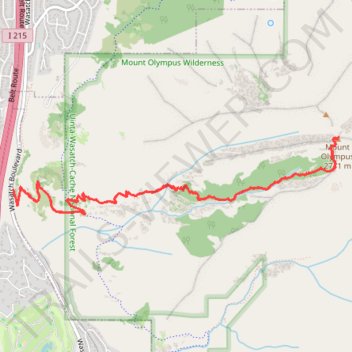
Mount Olympus Trail
Interactive trail map
Trail profile
- Distance: 7.0 mi
- Elevation gain: 1,244 m
- Maximum elevation: 2,723 m
- Elevation loss: 1,245 m
- Minimum elevation: 1,477 m
- Moving time: 3 h 1 m
- Moving speed: 2.3 mph
- Maximum speed: 7.4 mph
- Total time: 3 h 44 m
- Global speed: 1.9 mph
About this trail
Name: Mount Olympus Trail trail, distance, elevation, map, profile, GPS track
Start: Mount Olympus Trail, Salt Lake County, Utah, 84121, United States (40.65257 -111.80622)
Coordinates: 40.65051 -111.80625 40.65685 -111.77089
Other hiking, mountain biking, running and outdoor activity trails
Click on a trail to view its statistics, map and profile.
Mount Olympus Trail
United States > Utah > Salt Lake County
Embarking on the Mount Olympus Trail in Utah offers hikers a challenging ascent through diverse terrains, including dense forests and rocky outcrops. As you progress, the trail provides sweeping vistas of the Salt Lake Valley and the expansive Wasatch Mountain Range. Upon reaching the summit, you're rewarded…
Distance: 6.9 mi • Elevation gain: 1,245 m • Maximum elevation: 2,723 m
Mount Olympus Trail
United States > Utah > Salt Lake County
The Mount Olympus Trail is a challenging and rewarding hike near Salt Lake City, offering spectacular views of the surrounding valley, including glimpses of the Wasatch Mountains. As you ascend, the trail takes you through a variety of terrain, with steep switchbacks and rock steps leading to a thrilling final…
Distance: 6.6 mi • Elevation gain: 1,238 m • Maximum elevation: 2,722 m