Thank you for supporting this site ❤️
Make a donation
Make a donation
Gear up for your next adventure:
As an Amazon Associate, this site earns from qualifying purchases at no extra cost to you.
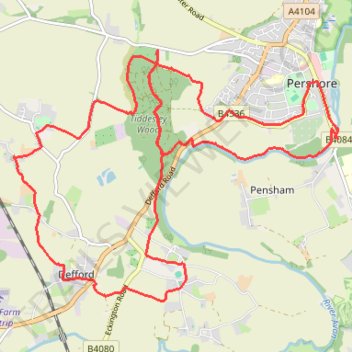
Around Tiddesley Wood
- Distance: 12.1 mi
- Elevation gain: 192 m
- Maximum elevation: 56 m
- Elevation loss: 193 m
- Minimum elevation: 11 m
- Moving time: 4 h 6 m
- Moving speed: 2.9 mph
- Maximum speed: 5.0 mph
- Total time: 5 h 25 m
- Global speed: 2.2 mph
Interactive trail map
Thank you for supporting this site ❤️
Make a donation
Make a donation
Gear up for your next adventure:
As an Amazon Associate, this site earns from qualifying purchases at no extra cost to you.
Trail profile
- Distance: 12.1 mi
- Elevation gain: 192 m
- Maximum elevation: 56 m
- Elevation loss: 193 m
- Minimum elevation: 11 m
- Moving time: 4 h 6 m
- Moving speed: 2.9 mph
- Maximum speed: 5.0 mph
- Total time: 5 h 25 m
- Global speed: 2.2 mph
Thank you for supporting this site ❤️
Make a donation
Make a donation
Gear up for your next adventure:
As an Amazon Associate, this site earns from qualifying purchases at no extra cost to you.
About this trail
Name: Around Tiddesley Wood trail, distance, elevation, map, profile, GPS track
Coordinates: 52.08463 -2.13130 52.11341 -2.07054
Topography: Wychavon topographic map, elevation, terrain
Thank you for supporting this site ❤️
Make a donation
Make a donation
Gear up for your next adventure:
As an Amazon Associate, this site earns from qualifying purchases at no extra cost to you.
Other hiking, mountain biking, running and outdoor activity trails
Click on a trail to view its statistics, map and profile.
Pershore
United Kingdom > England > Worcestershire > Wychavon > Pershore
Distance: 4.7 mi • Elevation gain: 80 m • Maximum elevation: 56 m