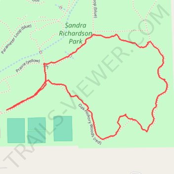
Sandra Richardson Park
- Distance: 1.3 mi
- Elevation gain: 10 m
- Maximum elevation: 254 m
- Elevation loss: 11 m
- Minimum elevation: 245 m
- Moving time: 32 m 6 s
- Moving speed: 2.4 mph
- Maximum speed: 3.7 mph
- Total time: 33 m 22 s
- Global speed: 2.3 mph
Interactive trail map
Trail profile
- Distance: 1.3 mi
- Elevation gain: 10 m
- Maximum elevation: 254 m
- Elevation loss: 11 m
- Minimum elevation: 245 m
- Moving time: 32 m 6 s
- Moving speed: 2.4 mph
- Maximum speed: 3.7 mph
- Total time: 33 m 22 s
- Global speed: 2.3 mph
About this trail
Name: Sandra Richardson Park trail, distance, elevation, map, profile, GPS track
Coordinates: 42.14983 -83.69573 42.15354 -83.68806
Other hiking, mountain biking, running and outdoor activity trails
Click on a trail to view its statistics, map and profile.
Oak-Hickory Woods Loop Trail
United States > Michigan > Washtenaw County > York Charter Township
Sandra Richardson State Park
Distance: 1.3 mi • Elevation gain: 12 m • Maximum elevation: 253 m