Upper Whites Creek Trail
- Distance: 1.8 mi
- Elevation gain: 188 m
- Maximum elevation: 2,020 m
- Elevation loss: 0 m
- Minimum elevation: 1,831 m
- Moving time: 33 m 52 s
- Moving speed: 3.2 mph
- Maximum speed: 4.8 mph
- Total time: 38 m 49 s
- Global speed: 2.8 mph
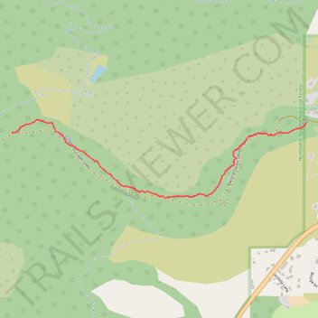
Interactive trail map
Trail profile
- Distance: 1.8 mi
- Elevation gain: 188 m
- Maximum elevation: 2,020 m
- Elevation loss: 0 m
- Minimum elevation: 1,831 m
- Moving time: 33 m 52 s
- Moving speed: 3.2 mph
- Maximum speed: 4.8 mph
- Total time: 38 m 49 s
- Global speed: 2.8 mph
About this trail
Name: Upper Whites Creek Trail trail, distance, elevation, map, profile, GPS track
Start: Upper Whites Creek Trail, Washoe County, Nevada, United States (39.38332 -119.84037)
End: Jones/Whites Creek Loop, Washoe County, Nevada, United States (39.38258 -119.86645)
Coordinates: 39.37814 -119.86645 39.38351 -119.84037
Other hiking, mountain biking, running and outdoor activity trails
Click on a trail to view its statistics, map and profile.
Day 1: Home to dispersed camping 60 mi E of Austin, NV
United States > Nevada > Washoe County > Reno
Distance: 129.5 mi • Elevation gain: 1,012 m • Maximum elevation: 1,563 m
Dry Pond Trail
United States > Nevada > Washoe County
Distance: 2.2 mi • Elevation gain: 107 m • Maximum elevation: 2,124 m