Stellenbosch Ride
- Distance: 31.6 mi
- Elevation gain: 1,358 m
- Maximum elevation: 351 m
- Elevation loss: 1,345 m
- Minimum elevation: 114 m
- Moving time: 3 h 20 m
- Moving speed: 9.4 mph
- Maximum speed: 24.1 mph
- Total time: 3 h 20 m
- Global speed: 9.4 mph
Interactive trail map
Trail profile
- Distance: 31.6 mi
- Elevation gain: 1,358 m
- Maximum elevation: 351 m
- Elevation loss: 1,345 m
- Minimum elevation: 114 m
- Moving time: 3 h 20 m
- Moving speed: 9.4 mph
- Maximum speed: 24.1 mph
- Total time: 3 h 20 m
- Global speed: 9.4 mph
About this trail
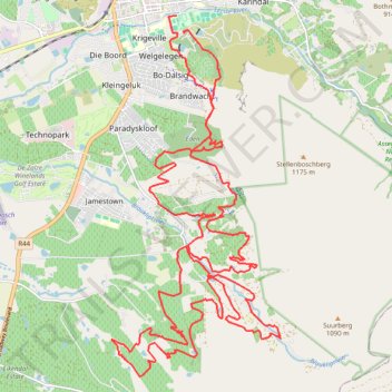
Name: Stellenbosch Ride trail, distance, elevation, map, profile, GPS track
Coordinates: -34.01722 18.85111 -33.93924 18.89488
Other hiking, mountain biking, running and outdoor activity trails
Click on a trail to view its statistics, map and profile.
Element Mont Marie
South Africa > Western Cape > Cape Winelands District Municipality > Stellenbosch Local Municipality
Distance: 1.9 mi • Elevation gain: 99 m • Maximum elevation: 262 m
Eden
South Africa > Western Cape > Cape Winelands District Municipality > Stellenbosch Local Municipality > Stellenbosch
Distance: 2.0 mi • Elevation gain: 112 m • Maximum elevation: 301 m