Thank you for supporting this site ❤️
Make a donation
Make a donation
Gear up for your next adventure:
As an Amazon Associate, this site earns from qualifying purchases at no extra cost to you.
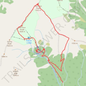
Loop hike via Camp Saddle, Hamilton Peak and Nervous Knob in Broken River Ski Area
- Distance: 6.9 mi
- Elevation gain: 949 m
- Maximum elevation: 1,923 m
- Elevation loss: 1,012 m
- Minimum elevation: 989 m
- Moving time: 4 h 12 m
- Moving speed: 1.6 mph
- Maximum speed: 4.6 mph
- Total time: 5 h 47 m
- Global speed: 1.2 mph
Interactive trail map
Thank you for supporting this site ❤️
Make a donation
Make a donation
Gear up for your next adventure:
As an Amazon Associate, this site earns from qualifying purchases at no extra cost to you.
Trail profile
- Distance: 6.9 mi
- Elevation gain: 949 m
- Maximum elevation: 1,923 m
- Elevation loss: 1,012 m
- Minimum elevation: 989 m
- Moving time: 4 h 12 m
- Moving speed: 1.6 mph
- Maximum speed: 4.6 mph
- Total time: 5 h 47 m
- Global speed: 1.2 mph
Thank you for supporting this site ❤️
Make a donation
Make a donation
Gear up for your next adventure:
As an Amazon Associate, this site earns from qualifying purchases at no extra cost to you.
About this trail
Name: Loop hike via Camp Saddle, Hamilton Peak and Nervous Knob in Broken River Ski Area trail, distance, elevation, map, profile, GPS track
End: Broken River Road, Selwyn District, Canterbury, 7580, New Zealand (-43.14173 171.70074)
Coordinates: -43.14173 171.67808 -43.11295 171.70398
Thank you for supporting this site ❤️
Make a donation
Make a donation
Gear up for your next adventure:
As an Amazon Associate, this site earns from qualifying purchases at no extra cost to you.
Other hiking, mountain biking, running and outdoor activity trails
Click on a trail to view its statistics, map and profile.