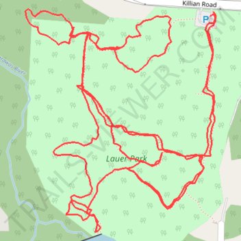
Lauer Park Trails
- Distance: 2.1 mi
- Elevation gain: 39 m
- Maximum elevation: 338 m
- Elevation loss: 40 m
- Minimum elevation: 325 m
- Moving time: 56 m 40 s
- Moving speed: 2.2 mph
- Maximum speed: 3.6 mph
- Total time: 59 m 43 s
- Global speed: 2.1 mph
Interactive trail map
Trail profile
- Distance: 2.1 mi
- Elevation gain: 39 m
- Maximum elevation: 338 m
- Elevation loss: 40 m
- Minimum elevation: 325 m
- Moving time: 56 m 40 s
- Moving speed: 2.2 mph
- Maximum speed: 3.6 mph
- Total time: 59 m 43 s
- Global speed: 2.1 mph
About this trail
Name: Lauer Park Trails trail, distance, elevation, map, profile, GPS track
Coordinates: 40.99242 -81.42688 40.99559 -81.42329