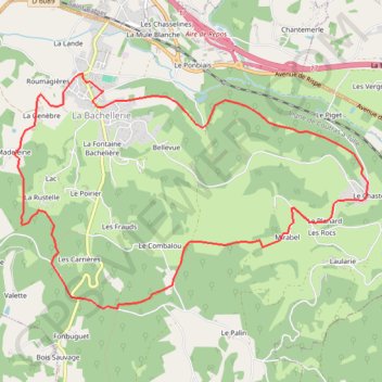
La Bachellerie boucle du Chastel
- Distance: 6.8 mi
- Elevation gain: 280 m
- Maximum elevation: 275 m
- Elevation loss: 280 m
- Minimum elevation: 137 m
Interactive trail map
Trail profile
- Distance: 6.8 mi
- Elevation gain: 280 m
- Maximum elevation: 275 m
- Elevation loss: 280 m
- Minimum elevation: 137 m
About this trail
Name: La Bachellerie boucle du Chastel trail, distance, elevation, map, profile, GPS track
Coordinates: 45.12704 1.14446 45.14748 1.18800
Other hiking, mountain biking, running and outdoor activity trails
Click on a trail to view its statistics, map and profile.
Chemin de Saint-Jacques-de-Compostelle
Switzerland > Geneva > Geneva
Distance: 694.6 mi • Elevation gain: 25,262 m • Maximum elevation: 1,430 m
GR 654 - Le chemin vers Saint-Jacques-de-Compostelle via Vézelay
France > Nouvelle-Aquitaine > Dordogne > Bergerac
Distance: 503.8 mi • Elevation gain: 9,631 m • Maximum elevation: 670 m