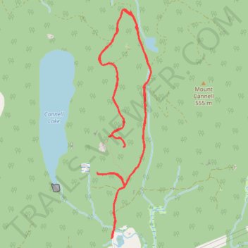
Hunter Trail
- Distance: 6.4 mi
- Elevation gain: 442 m
- Maximum elevation: 465 m
- Elevation loss: 442 m
- Minimum elevation: 183 m
- Moving time: 3 h 26 m
- Moving speed: 1.9 mph
- Maximum speed: 3.5 mph
- Total time: 5 h 15 m
- Global speed: 1.2 mph
Interactive trail map
Trail profile
- Distance: 6.4 mi
- Elevation gain: 442 m
- Maximum elevation: 465 m
- Elevation loss: 442 m
- Minimum elevation: 183 m
- Moving time: 3 h 26 m
- Moving speed: 1.9 mph
- Maximum speed: 3.5 mph
- Total time: 5 h 15 m
- Global speed: 1.2 mph
About this trail
Name: Hunter Trail trail, distance, elevation, map, profile, GPS track
Coordinates: 49.24815 -122.30501 49.27032 -122.29704
Other hiking, mountain biking, running and outdoor activity trails
Click on a trail to view its statistics, map and profile.