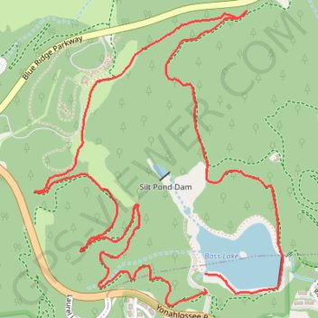
Bass Lake Loop in Blue Ridge Parkway
- Distance: 4.1 mi
- Elevation gain: 168 m
- Maximum elevation: 1,208 m
- Elevation loss: 157 m
- Minimum elevation: 1,084 m
- Moving time: 47 m 52 s
- Moving speed: 5.2 mph
- Maximum speed: 7.2 mph
- Total time: 47 m 52 s
- Global speed: 5.2 mph
Interactive trail map
Trail profile
- Distance: 4.1 mi
- Elevation gain: 168 m
- Maximum elevation: 1,208 m
- Elevation loss: 157 m
- Minimum elevation: 1,084 m
- Moving time: 47 m 52 s
- Moving speed: 5.2 mph
- Maximum speed: 7.2 mph
- Total time: 47 m 52 s
- Global speed: 5.2 mph
About this trail
Name: Bass Lake Loop in Blue Ridge Parkway trail, distance, elevation, map, profile, GPS track
Coordinates: 36.13919 -81.69563 36.15203 -81.68220
Other hiking, mountain biking, running and outdoor activity trails
Click on a trail to view its statistics, map and profile.
Flat Top Shortcuts
United States > North Carolina > Watauga County
Distance: 3.9 mi • Elevation gain: 175 m • Maximum elevation: 1,377 m