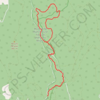
Murrindindi Cascades and Wilhelmina Falls Loop
- Distance: 14.3 mi
- Elevation gain: 860 m
- Maximum elevation: 673 m
- Elevation loss: 862 m
- Minimum elevation: 324 m
- Moving time: 3 h 24 m
- Moving speed: 4.2 mph
- Maximum speed: 12.5 mph
- Total time: 3 h 51 m
- Global speed: 3.7 mph
Interactive trail map
Trail profile
- Distance: 14.3 mi
- Elevation gain: 860 m
- Maximum elevation: 673 m
- Elevation loss: 862 m
- Minimum elevation: 324 m
- Moving time: 3 h 24 m
- Moving speed: 4.2 mph
- Maximum speed: 12.5 mph
- Total time: 3 h 51 m
- Global speed: 3.7 mph
About this trail
Name: Murrindindi Cascades and Wilhelmina Falls Loop trail, distance, elevation, map, profile, GPS track
Start: Murrindindi Road, Murrindindi, Shire of Murrindindi, Victoria, 3717, Australia (-37.45976 145.57180)
End: Murrindindi Road, Murrindindi, Shire of Murrindindi, Victoria, 3717, Australia (-37.45972 145.57193)
Coordinates: -37.45986 145.56260 -37.39874 145.58576
Other hiking, mountain biking, running and outdoor activity trails
Click on a trail to view its statistics, map and profile.
Tallarook - Eildon - Hurstbridge
Australia > Victoria > Tallarook
#Bike
Distance: 173.2 mi • Elevation gain: 4,897 m • Maximum elevation: 868 m
Wilhelmina Falls
Murrindindi River Natural Features and Scenic Reserve. #Hiking #Loop #Murrindindi
Distance: 7.8 mi • Elevation gain: 533 m • Maximum elevation: 673 m