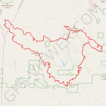
Bull and Jake Mountains MTB Loop
Interactive trail map
Trail profile
- Distance: 23.4 mi
- Elevation gain: 1,120 m
- Maximum elevation: 812 m
- Elevation loss: 1,118 m
- Minimum elevation: 464 m
About this trail
Name: Bull and Jake Mountains MTB Loop trail, distance, elevation, map, profile, GPS track
Coordinates: 34.56529 -84.18800 34.61727 -84.09514
Other hiking, mountain biking, running and outdoor activity trails
Click on a trail to view its statistics, map and profile.
North Georgia roads and trails to Springer Mountain via Benton MacKaye Trail in the Blue Ridge Wildlife Management Area
United States > Georgia > Lumpkin County > Dahlonega
Distance: 49.7 mi • Elevation gain: 2,068 m • Maximum elevation: 1,137 m