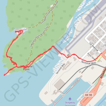
Yakutania Point trail in Skagway Alaska USA
- Distance: 2.0 mi
- Elevation gain: 121 m
- Maximum elevation: 31 m
- Elevation loss: 121 m
- Minimum elevation: 0 m
- Moving time: 55 m 34 s
- Moving speed: 2.2 mph
- Maximum speed: 6.1 mph
- Total time: 1 h 4 s
- Global speed: 2.0 mph
Interactive trail map
Trail profile
- Distance: 2.0 mi
- Elevation gain: 121 m
- Maximum elevation: 31 m
- Elevation loss: 121 m
- Minimum elevation: 0 m
- Moving time: 55 m 34 s
- Moving speed: 2.2 mph
- Maximum speed: 6.1 mph
- Total time: 1 h 4 s
- Global speed: 2.0 mph
About this trail
Name: Yakutania Point trail in Skagway Alaska USA trail, distance, elevation, map, profile, GPS track
Start: 400, 1st Avenue, Skagway, Alaska, 99840, United States (59.45399 -135.32090)
End: 18, Terminal Way, Skagway, Alaska, 99840, United States (59.45354 -135.32461)
Coordinates: 59.45213 -135.33701 59.45588 -135.32090