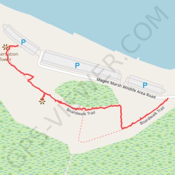
Boardwalk Trail
- Distance: 0.7 mi
- Elevation gain: 3 m
- Maximum elevation: 177 m
- Elevation loss: 4 m
- Minimum elevation: 173 m
- Moving time: 29 m 16 s
- Moving speed: 1.4 mph
- Maximum speed: 8.7 mph
- Total time: 49 m 53 s
- Global speed: 0.8 mph
Interactive trail map
Trail profile
- Distance: 0.7 mi
- Elevation gain: 3 m
- Maximum elevation: 177 m
- Elevation loss: 4 m
- Minimum elevation: 173 m
- Moving time: 29 m 16 s
- Moving speed: 1.4 mph
- Maximum speed: 8.7 mph
- Total time: 49 m 53 s
- Global speed: 0.8 mph
About this trail
Name: Boardwalk Trail trail, distance, elevation, map, profile, GPS track
End: Boardwalk Trail, Lucas County, Ohio, United States (41.62920 -83.19296)
Coordinates: 41.62622 -83.19351 41.62920 -83.18578