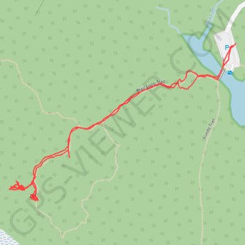
Blair Woods Trail
- Distance: 1.2 mi
- Elevation gain: 28 m
- Maximum elevation: 107 m
- Elevation loss: 29 m
- Minimum elevation: 82 m
- Moving time: 35 m 55 s
- Moving speed: 2.0 mph
- Maximum speed: 3.5 mph
- Total time: 1 h 41 m
- Global speed: 0.7 mph
Interactive trail map
Trail profile
- Distance: 1.2 mi
- Elevation gain: 28 m
- Maximum elevation: 107 m
- Elevation loss: 29 m
- Minimum elevation: 82 m
- Moving time: 35 m 55 s
- Moving speed: 2.0 mph
- Maximum speed: 3.5 mph
- Total time: 1 h 41 m
- Global speed: 0.7 mph
About this trail
Name: Blair Woods Trail trail, distance, elevation, map, profile, GPS track
Coordinates: 43.10656 -71.15392 43.10968 -71.14777
Other hiking, mountain biking, running and outdoor activity trails
Click on a trail to view its statistics, map and profile.
2026-06-23_11-48_Tue
United States > New Hampshire > Hillsborough County > Goffstown > Grasmere
Distance: 43.7 mi • Elevation gain: 643 m • Maximum elevation: 140 m