Make a donation
Gear up for your next adventure:
As an Amazon Associate, this site earns from qualifying purchases at no extra cost to you.
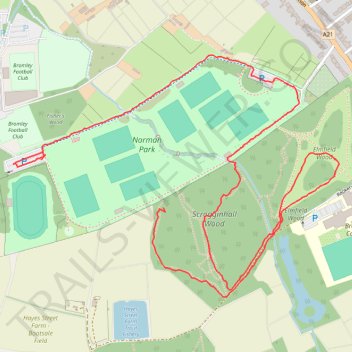
Norman Park, Scrogginhall Wood and Elmfield Wood
- Distance: 2.1 mi
- Elevation gain: 24 m
- Maximum elevation: 65 m
- Elevation loss: 26 m
- Minimum elevation: 52 m
- Moving time: 52 m 45 s
- Moving speed: 2.4 mph
- Maximum speed: 17.0 mph
- Total time: 56 m 36 s
- Global speed: 2.2 mph
Interactive trail map
Make a donation
Gear up for your next adventure:
As an Amazon Associate, this site earns from qualifying purchases at no extra cost to you.
Trail profile
- Distance: 2.1 mi
- Elevation gain: 24 m
- Maximum elevation: 65 m
- Elevation loss: 26 m
- Minimum elevation: 52 m
- Moving time: 52 m 45 s
- Moving speed: 2.4 mph
- Maximum speed: 17.0 mph
- Total time: 56 m 36 s
- Global speed: 2.2 mph
Make a donation
Gear up for your next adventure:
As an Amazon Associate, this site earns from qualifying purchases at no extra cost to you.
About this trail
Name: Norman Park, Scrogginhall Wood and Elmfield Wood trail, distance, elevation, map, profile, GPS track
Coordinates: 51.38440 0.02072 51.39050 0.03387
Topography: London topographic map, elevation, terrain
Make a donation
Gear up for your next adventure:
As an Amazon Associate, this site earns from qualifying purchases at no extra cost to you.
Other hiking, mountain biking, running and outdoor activity trails
Click on a trail to view its statistics, map and profile.
Scroginhall Wood Loop
United Kingdom > England > London
Distance: 2.1 mi • Elevation gain: 19 m • Maximum elevation: 64 m
Norman Park and Scrogginhall Wood loop
United Kingdom > England > London
Distance: 2.9 mi • Elevation gain: 28 m • Maximum elevation: 61 m
Scrogginhall Wood and Farm
United Kingdom > England > London
Distance: 2.5 mi • Elevation gain: 30 m • Maximum elevation: 68 m
Elmfield Wood
United Kingdom > England > London
Distance: 1.6 mi • Elevation gain: 25 m • Maximum elevation: 66 m
Make a donation
Gear up for your next adventure:
As an Amazon Associate, this site earns from qualifying purchases at no extra cost to you.
Loop walk in Elmfield Wood
United Kingdom > England > London Borough of Bromley > Bromley
Distance: 0.6 mi • Elevation gain: 8 m • Maximum elevation: 66 m