
Abraham Mountain "Endless Gully of Pain" route
- Distance: 4.3 mi
- Elevation gain: 1,732 m
- Maximum elevation: 2,812 m
- Elevation loss: 279 m
- Minimum elevation: 1,355 m
- Moving time: 3 h 51 m
- Moving speed: 1.1 mph
- Maximum speed: 2.6 mph
- Total time: 10 h 2 m
- Global speed: 0.4 mph
Interactive trail map
Trail profile
- Distance: 4.3 mi
- Elevation gain: 1,732 m
- Maximum elevation: 2,812 m
- Elevation loss: 279 m
- Minimum elevation: 1,355 m
- Moving time: 3 h 51 m
- Moving speed: 1.1 mph
- Maximum speed: 2.6 mph
- Total time: 10 h 2 m
- Global speed: 0.4 mph
About this trail
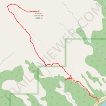
Name: Abraham Mountain "Endless Gully of Pain" route trail, distance, elevation, map, profile, GPS track
Start: Highway 11, Clearwater County, Alberta, Canada (52.24409 -116.43880)
End: Abraham Mountain Route, Clearwater County, Alberta, Canada (52.26801 -116.46456)
Coordinates: 52.24409 -116.47812 52.26985 -116.43880
Other hiking, mountain biking, running and outdoor activity trails
Click on a trail to view its statistics, map and profile.
Vision Quest - Epiphany Peak - Bright Star Peak
Canada > Alberta > Clearwater County
Route traversing Vision Quest Ridge to Vision Quest Ridge Peak, then traversing to Epiphany Peak, Bright Star Peak, then back to the trailhead
Distance: 20.9 mi • Elevation gain: 3,631 m • Maximum elevation: 2,932 m