Thank you for supporting this site ❤️
Make a donation
Make a donation
Gear up for your next adventure:
As an Amazon Associate, this site earns from qualifying purchases at no extra cost to you.
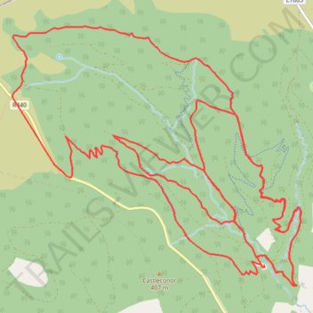
Slieve Blooms MTB
- Distance: 13.1 mi
- Elevation gain: 536 m
- Maximum elevation: 454 m
- Elevation loss: 536 m
- Minimum elevation: 212 m
- Moving time: 1 h 42 m
- Moving speed: 7.6 mph
- Maximum speed: 21.4 mph
- Total time: 1 h 53 m
- Global speed: 6.9 mph
Interactive trail map
Thank you for supporting this site ❤️
Make a donation
Make a donation
Gear up for your next adventure:
As an Amazon Associate, this site earns from qualifying purchases at no extra cost to you.
Trail profile
- Distance: 13.1 mi
- Elevation gain: 536 m
- Maximum elevation: 454 m
- Elevation loss: 536 m
- Minimum elevation: 212 m
- Moving time: 1 h 42 m
- Moving speed: 7.6 mph
- Maximum speed: 21.4 mph
- Total time: 1 h 53 m
- Global speed: 6.9 mph
Thank you for supporting this site ❤️
Make a donation
Make a donation
Gear up for your next adventure:
As an Amazon Associate, this site earns from qualifying purchases at no extra cost to you.
About this trail
Name: Slieve Blooms MTB trail, distance, elevation, map, profile, GPS track
Coordinates: 53.06593 -7.59775 53.08816 -7.55656
Thank you for supporting this site ❤️
Make a donation
Make a donation
Gear up for your next adventure:
As an Amazon Associate, this site earns from qualifying purchases at no extra cost to you.