Thank you for supporting this site ❤️
Make a donation
Make a donation
Gear up for your next adventure:
As an Amazon Associate, this site earns from qualifying purchases at no extra cost to you.
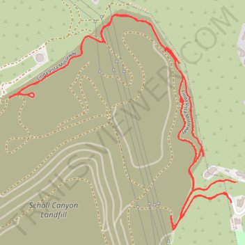
Outskirts of Scholl Canyon Landfill
- Distance: 2.9 mi
- Elevation gain: 176 m
- Maximum elevation: 481 m
- Elevation loss: 177 m
- Minimum elevation: 434 m
- Moving time: 56 m 40 s
- Moving speed: 3.0 mph
- Maximum speed: 4.1 mph
- Total time: 1 h 3 m
- Global speed: 2.7 mph
Interactive trail map
Thank you for supporting this site ❤️
Make a donation
Make a donation
Gear up for your next adventure:
As an Amazon Associate, this site earns from qualifying purchases at no extra cost to you.
Trail profile
- Distance: 2.9 mi
- Elevation gain: 176 m
- Maximum elevation: 481 m
- Elevation loss: 177 m
- Minimum elevation: 434 m
- Moving time: 56 m 40 s
- Moving speed: 3.0 mph
- Maximum speed: 4.1 mph
- Total time: 1 h 3 m
- Global speed: 2.7 mph
Thank you for supporting this site ❤️
Make a donation
Make a donation
Gear up for your next adventure:
As an Amazon Associate, this site earns from qualifying purchases at no extra cost to you.
About this trail
Name: Outskirts of Scholl Canyon Landfill trail, distance, elevation, map, profile, GPS track
Start: Glen Oaks Road, Pasadena, Los Angeles County, California, 91102, United States (34.15888 -118.18389)
End: Glen Oaks Road, Pasadena, Los Angeles County, California, 91102, United States (34.15884 -118.18389)
Coordinates: 34.15792 -118.19294 34.16517 -118.18372
Thank you for supporting this site ❤️
Make a donation
Make a donation
Gear up for your next adventure:
As an Amazon Associate, this site earns from qualifying purchases at no extra cost to you.