Thank you for supporting this site ❤️
Make a donation
Make a donation
Gear up for your next adventure:
As an Amazon Associate, this site earns from qualifying purchases at no extra cost to you.
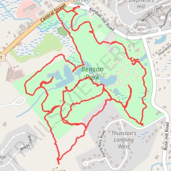
Woodland trails around Benson Park, Hudson, NH
- Distance: 5.3 mi
- Elevation gain: 123 m
- Maximum elevation: 97 m
- Elevation loss: 127 m
- Minimum elevation: 50 m
- Moving time: 1 h 52 m
- Moving speed: 2.8 mph
- Maximum speed: 24.3 mph
- Total time: 1 h 59 m
- Global speed: 2.7 mph
Interactive trail map
Thank you for supporting this site ❤️
Make a donation
Make a donation
Gear up for your next adventure:
As an Amazon Associate, this site earns from qualifying purchases at no extra cost to you.
Trail profile
- Distance: 5.3 mi
- Elevation gain: 123 m
- Maximum elevation: 97 m
- Elevation loss: 127 m
- Minimum elevation: 50 m
- Moving time: 1 h 52 m
- Moving speed: 2.8 mph
- Maximum speed: 24.3 mph
- Total time: 1 h 59 m
- Global speed: 2.7 mph
Thank you for supporting this site ❤️
Make a donation
Make a donation
Gear up for your next adventure:
As an Amazon Associate, this site earns from qualifying purchases at no extra cost to you.
About this trail
Name: Woodland trails around Benson Park, Hudson, NH trail, distance, elevation, map, profile, GPS track
Coordinates: 42.76048 -71.41214 42.77129 -71.40080
Thank you for supporting this site ❤️
Make a donation
Make a donation
Gear up for your next adventure:
As an Amazon Associate, this site earns from qualifying purchases at no extra cost to you.