Rainbow Falls, Turtleback Falls and Drift Falls via Rainbow Falls Trail
The Rainbow Falls Trail in North Carolina's Nantahala National Forest offers hikers a scenic journey along the Horsepasture River, leading to three remarkable waterfalls. The trail first reveals the impressive Rainbow Falls, where water cascades down a towering cliff, often creating vibrant rainbows in its mist. Continuing upstream, hikers encounter Turtleback Falls, known for its unique curved rock formation, and finally Drift Falls, a picturesque slide waterfall visible from the trail's end. #Hiking #Waterfall #Forest #River #Nature
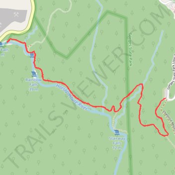
- Distance: 4.0 mi
- Elevation gain: 244 m
- Maximum elevation: 887 m
- Elevation loss: 244 m
- Minimum elevation: 773 m
- Moving time: 1 h 48 m
- Moving speed: 2.2 mph
- Maximum speed: 3.9 mph
- Total time: 2 h 1 m
- Global speed: 2.0 mph
Interactive trail map
Trail profile
- Distance: 4.0 mi
- Elevation gain: 244 m
- Maximum elevation: 887 m
- Elevation loss: 244 m
- Minimum elevation: 773 m
- Moving time: 1 h 48 m
- Moving speed: 2.2 mph
- Maximum speed: 3.9 mph
- Total time: 2 h 1 m
- Global speed: 2.0 mph
About this trail
Name: Rainbow Falls, Turtleback Falls and Drift Falls via Rainbow Falls Trail trail, distance, elevation, map, profile, GPS track
Start: Rainbow Falls Trail, Transylvania County, North Carolina, United States (35.08872 -82.95182)
End: Rainbow Falls Trail, Transylvania County, North Carolina, United States (35.08874 -82.95180)
Coordinates: 35.08542 -82.96889 35.09395 -82.95151
Other hiking, mountain biking, running and outdoor activity trails
Click on a trail to view its statistics, map and profile.