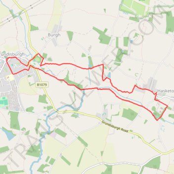
Walk - Hasketon and Grundisburgh
- Distance: 4.7 mi
- Elevation gain: 62 m
- Maximum elevation: 32 m
- Elevation loss: 62 m
- Minimum elevation: 14 m
- Moving time: 1 h 56 m
- Moving speed: 2.4 mph
- Maximum speed: 3.6 mph
- Total time: 2 h 22 m
- Global speed: 2.0 mph
Interactive trail map
Trail profile
- Distance: 4.7 mi
- Elevation gain: 62 m
- Maximum elevation: 32 m
- Elevation loss: 62 m
- Minimum elevation: 14 m
- Moving time: 1 h 56 m
- Moving speed: 2.4 mph
- Maximum speed: 3.6 mph
- Total time: 2 h 22 m
- Global speed: 2.0 mph
About this trail
Name: Walk - Hasketon and Grundisburgh trail, distance, elevation, map, profile, GPS track
Start: Tymmes Place, Hasketon, East Suffolk, Suffolk, England, IP13 6JD, United Kingdom (52.10756 1.28480)
End: Tymmes Place, Hasketon, East Suffolk, Suffolk, England, IP13 6JD, United Kingdom (52.10749 1.28469)
Coordinates: 52.10320 1.24630 52.11367 1.28749
Topography: East Suffolk topographic map, elevation, terrain