Thank you for supporting this site ❤️
Make a donation
Make a donation
Gear up for your next adventure:
As an Amazon Associate, this site earns from qualifying purchases at no extra cost to you.
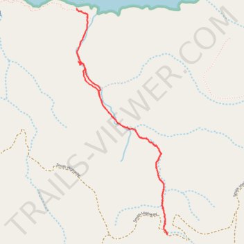
Lobo Canyon Trail
- Distance: 3.1 mi
- Elevation gain: 159 m
- Maximum elevation: 98 m
- Elevation loss: 157 m
- Minimum elevation: 3 m
- Moving time: 1 h 43 m
- Moving speed: 1.8 mph
- Maximum speed: 3.5 mph
- Total time: 2 h 49 m
- Global speed: 1.1 mph
Interactive trail map
Thank you for supporting this site ❤️
Make a donation
Make a donation
Gear up for your next adventure:
As an Amazon Associate, this site earns from qualifying purchases at no extra cost to you.
Trail profile
- Distance: 3.1 mi
- Elevation gain: 159 m
- Maximum elevation: 98 m
- Elevation loss: 157 m
- Minimum elevation: 3 m
- Moving time: 1 h 43 m
- Moving speed: 1.8 mph
- Maximum speed: 3.5 mph
- Total time: 2 h 49 m
- Global speed: 1.1 mph
Thank you for supporting this site ❤️
Make a donation
Make a donation
Gear up for your next adventure:
As an Amazon Associate, this site earns from qualifying purchases at no extra cost to you.
About this trail
Name: Lobo Canyon Trail trail, distance, elevation, map, profile, GPS track
Start: Lobo Canyon Trail, Santa Barbara County, California, United States (34.00326 -120.09108)
End: Smith Highway, Santa Barbara County, California, United States (34.00313 -120.09105)
Coordinates: 34.00313 -120.09920 34.01988 -120.09105
Thank you for supporting this site ❤️
Make a donation
Make a donation
Gear up for your next adventure:
As an Amazon Associate, this site earns from qualifying purchases at no extra cost to you.